Our world is full of amazing things to see, cool places to go, and interesting people to meet. But these places and people aren't all near where we live, most don't even live on the same continent that we do! Now, you might say, "I live on a continent? I thought I lived in a town!" Well, you do live in a town, but also on a continent, almost everyone of Earth does! A continent is a large - and I mean REALLY LARGE! - piece of land. In fact, their are seven continents on Earth. Most continents have many countries inside of them. If you live in the Unites States, you share a continent with the countries of Canada, Mexico, and several little countries in Central America, such a Guatemala and Honduras. Also, you share your continent with island countries in the Caribbean Sea such as Cuba and Haiti, and even Greenland, the world's largest island is part of the North American Continent! Now that is a lot of sharing! Our world is full of amazing things to see, cool places to go, and interesting people to meet. But these places and people aren't all near where we live, most don't even live on the same continent that we do! Now, you might say, "I live on a continent? I thought I lived in a town!" Well, you do live in a town, but also on a continent, almost everyone of Earth does! A continent is a large - and I mean REALLY LARGE! - piece of land. In fact, their are seven continents on Earth. Most continents have many countries inside of them. If you live in the Unites States, you share a continent with the countries of Canada, Mexico, and several little countries in Central America, such a Guatemala and Honduras. Also, you share your continent with island countries in the Caribbean Sea such as Cuba and Haiti, and even Greenland, the world's largest island is part of the North American Continent! Now that is a lot of sharing!
Now, let's get back to the seven continents. We just talked about North America, but there is also a South America. The Amazon Rainforest is one of the many places located here. There is also Australia, Africa, Antarctica, Asia, and Europe. We are going to visit all of these continents and learn a bit about what makes them special over the next few months.
But now, we are going to learn how to find these continents on Earth using some special ways of measuring.
When you want to measure how long something is, we use inches or feet or centimeters. If we want to know how much something weighs, we use pounds or grams or ounces. Well, the Earth has a special kind of measurement, too.
Let's watch a video!
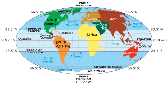
We measure the length around the Earth by degrees called latitude. We measure the top to bottom of the Earth by degrees called longitude. The lines divide the Earth into sections on maps. They are helpful in letting us know where things are on Earth.

Lines of Longitude - Meridians
Meridians run from the top of the Earth, the North Pole, all the way to the bottom,, ending at the South Pole. These lines are measured in degrees with longitude.They are called Lines of Longitude or Meridian Lines. They start at the Prime Meridian which is 0 degrees. The Prime Meridian runs through Greenwich, England.This is the line where everything is measured East or West from. Can you find the Prime Meridian on the map above?
An easy way to remember longitude, is to remember they measure the long way up and down the Earth!
Directly on the other side of the Earth, at 180 degrees, runs the International Date Line. Now, it is a little different, because it does not run in a straight line, but instead zigzags a little down the earth from the North Pole to the South Pole. This is the line where a new day starts each day on Earth.
Can you find it on the map below?
Let's watch a video!

The zig-zagging International Date Line |

This is how the Earth looks for each new day on the International Date Line - image by Arnaudf |
 |
 |
Lines of Latitude - Parallels
Parallels run around the Earth, kind of like how you would wear a belt. Unlike meridians, parallels connect with themselves, going completely around the Earth. In fact, the most important parallel runs around the exact middle of the Earth like it was wearing a belt. This is called the Equator. The equator is 24,901.55 miles long, and is 0 degrees latitude.
Let's watch a video!
Everything south of the Equator is measured
in degrees south. Everything north is measured in degrees north. That way, we can tell if something is north or south of the Equator! Can you find the Equator on the map you found the Prime Meridian on?
Now, the Equator is the central latitude line we measure all the other parallels from. If we move north of the Equator, we have many parallels, but four of them are especially important.
The first one we encounter is called the Tropic of Cancer. The Tropic of Cancer is located at 23.5 degrees North of the Equator. Can you find it on the map below?
Now,
if you look south of the Equator, at 23.5 degrees South, you will find the Tropic of Capricorn. Everything between the Tropic of Cancer and the Tropic of Capricorn is considered the Tropics. What are the Tropics? Well, it is simply an area of the Earth that receives almost the same amount of sunlight all year long. There are no great seasonal changes in the Tropics, and it is always warm. Many of the great jungles of the world are found in the tropics, and hurricanes, typhoons, and cyclones all form in the tropical oceans. Can you find the Tropic of Cancer on the map above?
As we continue moving north up the Earth, we keep traveling very far almost to the top of the Earth. Located at
66.5 degrees North is the Arctic Circle. Everything north of the Arctic Circle will receive at least one full day each year where the sun will not set on the horizon, and one full day that the sun will not rise above the horizon. This is caused by the tilt of the Earth towards the Sun as it rotates. The area north, or above, the Arctic Circle remains very cool and has long, cold, dark winters. Can you find the Arctic Circle on the map above?
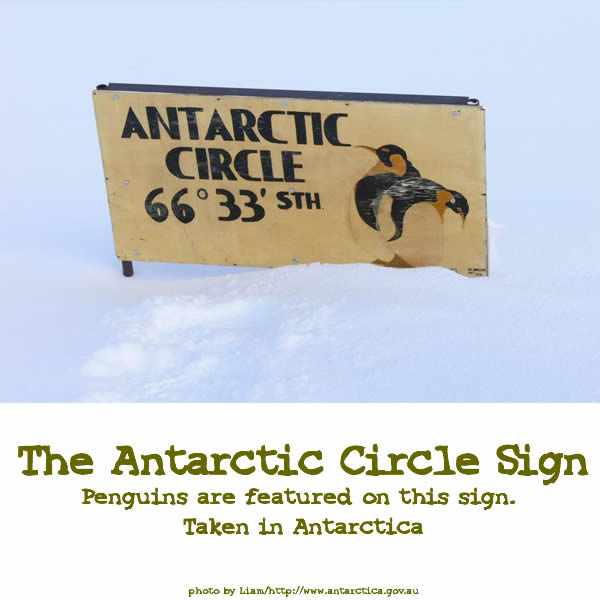
Our last parallel is the Antarctic Circle. It is located at
66.5 degrees South of the Equator. Similar to the Arctic Circle, everything south of the Arctic Circle will receive at least one full day each year where the sun will not set on the horizon, and one full day that the sun will not rise above the horizon. This is also caused by the tilt of the Earth towards the Sun as it rotates. The area south, or below, the Antarctic Circle is very cold and frozen, and also has long, cold, dark winters. Can you find the Antarctic Circle on the map above?
Let's watch a video!
Now, check out these pictures from around the world taken at the important parallels!
 |
 |
What We Learned in This Lesson:
* We learned that continents are very large pieces of land. The Earth has seven of them.
* Asia, Antarctica, Africa, North America, South America, Australia, and Europe are the seven continents on Earth.
* Continents can have many countries in them.
* To find the continents on Earth, we use special measurments by degrees.
*
We use longitude to measure the long way from North Pole to South Pole.
* We use latitude to measure up and down like belts around the earth.
* Longitude lines are also called meridians, latitude lines are also called parallels.
* The most important Meridians are the Prime Meridian at 0 degrees, and the International Date Line at 180 degrees.
* The most important parallels are the Equator at the center of the Earth, the Tropic of Cancer at 23.5 degrees north and Tropic of Capricorn at 23.5 degrees south
and at the top of the Earth, the Arctic Circle at 66.5 degrees north, and at the bottom of the Earth the Antarctic Circle at 66.5 degrees south.
* The area between the Tropics of Cancer and Capricorn are called the Tropics. It is warm here.
* Above or below the Arctic and Antarctic circles, at least one day a year has 24 hours of sunshine or 24 hours of nightime because of the tilt of the Earth. It is cold here.
Downloads For Your Workbook:
Map- Download the map, and label the 5 important parallels and 2 important meridians that you have just learned.
Info Sheet - Answer the questions on the info sheet for your book, and put both papers into your Tour the Continents notebook.
|
Banana Peels
The Arctic Circle, Antarctic Circle and Tropics parallels actually change every year, drifting as much as 2 degrees every 40,000 years! |
|